This road goes just about due south and forks a little more than half of the way down, one fork heading south east to Spili and Aghia Galini , and flanking the southwest side of the Kedros mountains on the west side of the Amari valley, another fork heading south to Preveli and southwest to Plakias/ leaving initially from the center of the city of Rethymnon.
 Whichever
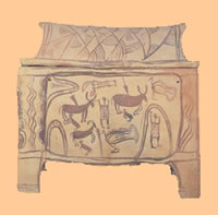
route you take, the scenery is fabulous. The Minoan cemetery at Armeni has been excavated, and many larnaxes (photo left)(burial chests/ clay
coffins) found, as well as figurines and grave gifts. (open Mon-Fri 9am-3pm). Seven acres of chamber
tombs were found there, dating from the 2nd millennium BC. The finds from this site are on display at the archaeological
museums in Heraklion and Rethymnon. The cemetery is in an oak forest. In fact, the area between the cemetery site and the
village is a forest conservation area with pine, cypress and oak trees.
Whichever
route you take, the scenery is fabulous. The Minoan cemetery at Armeni has been excavated, and many larnaxes (photo left)(burial chests/ clay
coffins) found, as well as figurines and grave gifts. (open Mon-Fri 9am-3pm). Seven acres of chamber
tombs were found there, dating from the 2nd millennium BC. The finds from this site are on display at the archaeological
museums in Heraklion and Rethymnon. The cemetery is in an oak forest. In fact, the area between the cemetery site and the
village is a forest conservation area with pine, cypress and oak trees.
The village of Armeni was named for Armenian soldiers who were given land grants here during the 10th century after Nikeforos Phokas retook Crete from the Arabs.
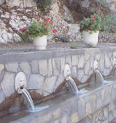 Spili is a nice
town below a mountainside, with a wonderful Venetian lion
head fountain in the main platia (photo right), the water pouring out of the mouths of a long row of lion heads (nineteen, to be
exact). A cool shady place. There are nice winding streets in the upper part of the village with some old kalderimia
(cobbled streets).
Spili is a nice
town below a mountainside, with a wonderful Venetian lion
head fountain in the main platia (photo right), the water pouring out of the mouths of a long row of lion heads (nineteen, to be
exact). A cool shady place. There are nice winding streets in the upper part of the village with some old kalderimia
(cobbled streets).
From Spili you can walk to Gerakari in the Amari Valley, or to Lampini, where the Byzantine church was burned by the Turks in 1827 (during the War of Independence) with the villagers inside. That fragments of frescoes remain is a wonder.
Rethymno Prefecture Continued: 1 | 2 | 3 | 4 | 5 | 6 | 7 | 8 | 9 | 10 | 11 | 12 | 13 | 14 | 15 | 16 | 17 | 18 | 19 | 20

Why not enjoy Harry's Free Musical Compositions while you read this site? (opens seperately)
©Harry's Greece Travel Guides