 The main resort in east Pilio is at Aghios Ioannis, a place which got
built very fast and without much taste or environmental discretion. There is a campsite to the south, and Plaka beach to the north, where one can
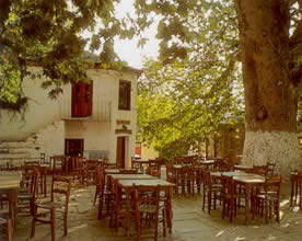
escape the worst of it somewhat. The all important village square with its plane tree left.
The main resort in east Pilio is at Aghios Ioannis, a place which got
built very fast and without much taste or environmental discretion. There is a campsite to the south, and Plaka beach to the north, where one can
escape the worst of it somewhat. The all important village square with its plane tree left.
Nearby Damouhari is a little village with a pretty port, but it too has been discovered, and the usual kind of development ensued, though sparing the seafront area itself with its pebble beach, Venetian castle, and some good eating places.
From here you can walk to Tsangaradha in about an hour, along an old kalderimi (cobbled road) with views of villages along the way.
 Tsangarada, at an altitude of 499 meters (1636 feet), is set in oak and plane forests, and is the second biggest village
in northeast Pilio, divided, like Zagora, into four different neighborhoods. In the one called Aghia Paraskevi yet another claim to having the
biggest plane tree in Greece is made. To the northwest Mouressi, has good tavernas. You can walk to Mylopotamos
in about 1 ½ hours via a couple of different paths. There are two coves with natural tunnels in the rocks between them, and Falistra Beach to the
north (also accessible on foot from Damouhari). To the southeast are Limnionas and Lambinou, the former being the larger and better, but requiring
some walking, either from the village of Lambinou or along the coast. Nearby Xourikhti (which you can walk to from Tsangaradha) is
the hub for more treks, one of which crosses the peninsula westward and ends up in the village of Milies (which means 'apple trees'). This hike
takes about three hours.
Tsangarada, at an altitude of 499 meters (1636 feet), is set in oak and plane forests, and is the second biggest village
in northeast Pilio, divided, like Zagora, into four different neighborhoods. In the one called Aghia Paraskevi yet another claim to having the
biggest plane tree in Greece is made. To the northwest Mouressi, has good tavernas. You can walk to Mylopotamos
in about 1 ½ hours via a couple of different paths. There are two coves with natural tunnels in the rocks between them, and Falistra Beach to the
north (also accessible on foot from Damouhari). To the southeast are Limnionas and Lambinou, the former being the larger and better, but requiring
some walking, either from the village of Lambinou or along the coast. Nearby Xourikhti (which you can walk to from Tsangaradha) is
the hub for more treks, one of which crosses the peninsula westward and ends up in the village of Milies (which means 'apple trees'). This hike
takes about three hours.
More Mt. Pilion (Pilio, Pelio) Magnesia Prefecture Page 1 | 2 | 3 | 4 | 5 | 6 | 7 | 8

Why not enjoy Harry's Free Musical Compositions while you read this site? (opens seperately)
©Harry's Greece Travel Guides