East of Lafkos you pass through Promyri, which lies along a slope well-concealed from the sea (and during previous centuries,
pirate attacks). In three hours you can walk from here to Platania on the southernmost coast near the middle of the boot that forms
the bottom of Pilio peninsula. Paralia Mourtia, on down the road towards the east and the heel of the boot, is a very small beach,
but there's a better (and more visited one) to the south at Paralia Lyris. Katiyiorgis is the biggest place around 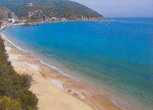 down in these
parts, with many fishing boats and yachts, and some package tourism, as well as tavernas and rooms.
down in these
parts, with many fishing boats and yachts, and some package tourism, as well as tavernas and rooms.
The cove of Vlahorema can be reached by path from near there, and offers more seclusion and a sandy beach. From there you can continue on foot to Vromoneri.This part of the boot is only three nautical miles from Skiathos and the northern tip of long Evia is just across the water as well. Kastri, at the bottom of the heel of Pilio, is set in a sandy bay, a taverna and a campsite, as well as some rooms.
Platania/Platanis (beach left) is named for the plane trees (called 'platania' in Greek), which hem the stream which has its estuary here. Plane trees are, in fact, found almost everywhere in Greece along streams and are very beautiful with their large knobbly trunks and their broad deciduous canopies and fuzzy seed-pods.
Platania is a big resort, with some apartment complexes, and a predictably crowded beach (not overly large), but there's a campsite nearby, and a path inland and along the coast which will take you in ten minutes to a better one at Mikro beach (which means, ironically, 'small' in Greek.
More Mt. Pilion (Pilio, Pelio) Magnesia Prefecture Page 1 | 2 | 3 | 4 | 5 | 6 | 7 | 8

Why not enjoy Harry's Free Musical Compositions while you read this site? (opens seperately)
©Harry's Greece Travel Guides